A traveler and scholar who edited in 1840 his cornerstone piece "La Turquie d'Europe" . He traced almost precisely the borderlines separating the different races in Macedonia.
The famous Slavicist provides valuable data concerning the territories inhabited by Bulgarians on the Balkans and, particularly, in Macedonia.
 Map
of G. Lejean, French (1861).
Map
of G. Lejean, French (1861).
Lejean was sent in a journey to the Ottoman Empire to gather information for the French government. His observances of the ethnic composition of the areas he visited produced this map.
 Map
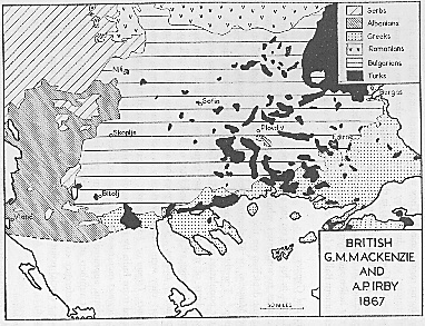
of G. M. Mackenzie and A.P. Irby, British (1867).
Map
of G. M. Mackenzie and A.P. Irby, British (1867).
The two ladies, Mackenzie and Irby, traveled through the Balkans to explore the ethnography of the peninsula.
 Map
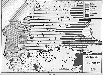
of H. Kiepert, German (1876).
Map
of H. Kiepert, German (1876).
Kiepert was a professor at the University of Berlin. He had knowledge of Balkan history. He also inquired in official sources in Istanbul and was influenced by the Greek historian P. Aravantinos (1856-7).
 Map
of K. Sax, Austrian (1878).
Map
of K. Sax, Austrian (1878).
Karl Sax was a consul of the Austria-Hungary Empire at Adrianople. He was well acquainted with Balkan affairs and had cultivated an intellectual interest in cartography. He made use of previous maps and official reports of populations by Austrian and Bulgarian offices.
 Map
by the German Foreign Office (1940).
Map
by the German Foreign Office (1940).
This highly detailed map was produced by the Geographical Division of the German Foreign Office and it was based on local official information.
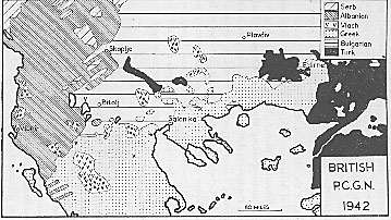 British
P.C.G.N. (1942).
British
P.C.G.N. (1942).
The Permanent Committee on Geographical Names for British Official Use produced this map in 1942. The method used was a simple shading of linguistic zones.